


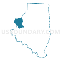
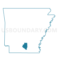
Voting District 7W, Calhoun County, Arkansas
About
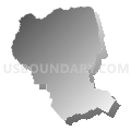
Outline

Summary
| Unique Area Identifier | 526038 |
| Name | Voting District 7W |
| County | Calhoun County |
| State | Arkansas |
| Area (square miles) | 27.98 |
| Land Area (square miles) | 27.98 |
| Water Area (square miles) | 0.00 |
| % of Land Area | 100.00 |
| % of Water Area | 0.00 |
| Latitude of the Internal Point | 33.61402360 |
| Longtitude of the Internal Point | -92.67834120 |
Maps

Graphs
Select a template below for downloading or customizing gragh for Voting District 7W, Calhoun County, Arkansas


Neighbors
Neighoring Voting District (by Name) Neighboring Voting District on the Map
- Bradley Voting District, Ouachita County, AR
- Cleveland Voting District, Ouachita County, AR
- Voting District 6, Calhoun County, AR
- Voting District 7, Calhoun County, AR
Top 10 Neighboring County Subdivision (by Population) Neighboring County Subdivision on the Map
- Bradley township, Ouachita County, AR (2,119)
- Township 7, Calhoun County, AR (687)
- Township 6, Calhoun County, AR (568)
- Cleveland township, Ouachita County, AR (232)
Top 10 Neighboring Unified School District (by Population) Neighboring Unified School District on the Map
- Harmony Grove School District, AR (5,284)
- Hampton School District, AR (4,062)
- Bearden School District, AR (3,480)